News:
| GAIA DR3 | 2024/02/25 10:59 |
Cartes du Ciel is free software released under the terms of the
 GNU General Public License
News:
| GAIA DR3 | 2024/02/25 10:59 |
Cartes du Ciel is free software released under the terms of the
 GNU General Public License
 icon in the object toolbar): Click on an object label.
In any detailed information window you can distinguish 4 paragraphs with their specific sorts of data.
For stars and deep sky objects, this paragraph contains static information about the object which was retrieved from the catalog. For these kinds of objects, they ususally will begin with the object type, catalog short name, the catalog identification, and the relative magnitude. The rest of this content depends entirely on the catalog from which the data is retrieved.
For Solar system objects, you can find information like the object type, and the object identification (name). Please forgive SkyChart when it shows you the Sun as a planet. All other information in this paragraph is dynamically calculated from the ephemeris data. This information depends on the type of solar system object you 're dealing with.
The first line of this paragraph, starting with Coordinates:, informs you to which of the equatorial coordinate systems the chart is set. The chart can show you on several coordinates in the equatorial systems, for example at the status bar. You can specify the equatorial coordinate system of your chart by the tab Chart, Coordinates from the menu by setup → Chart, Coordinates, in the type of coordinates part.
The other lines show you the coordinates of your object in the specified coordinate systems. Here, you can find the equatorial systems (apparent and mean), and also in the ecliptic - and galactic systems.
Here you find specific data relating to your position and time. So there is the name of the site you are observing from with the local date and time. Next, you will find the times in UT and local sideral time. Then there is the positional data for the date and time that was used in the calculation: local hour angle, azimuth and altitude. At the and you can find data about the time and position of rise, culmination and set; unless you are dealing with a circumpolair object. Then there's only information about the culmination.
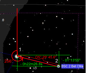
 Here you can find the distance and angle between two objects that you consecutively selected. This data can only reliably calculated when you select the objects from one single calculated chart or list. (A time difference combined with the dynamics of solar system objects can't lead to a precise value.) So, in order to retrieve distances, it can be wise to uncheck the Auto-refresh every checkbox, or to set the auto refresh time to a value so that there's time enough for you to select your objects.
First there is the line that says which objects you selected for the measurement. The next line shows the seperation in degrees of arc in sexagesimal format, and the angle measured from the previous to the last selected object. This angle takes the celestial North as zero reference, and increases by East, South, West. The picture is pretty self explanatory. About the angle: when you are on the Northern hemisphere and your face is directed south, the East will be at the left hand side.
The last line shows you the offset in sexagesimal hours and sexagesimal degrees in the equatorial coordination system.